Urban data is an informal description for all the data that is collected in cities, about people or about things. It can be used to make our life better, but, as Black Mirror shows, our personal data (our “digital fingerprint”) can be used to make our life impossible, too. It can also be used to do business with us, the consumer, and sell us goods which we never even knew we would want. Or, as we now know from the Facebook and Cambridge Analytica scandal, to try to convince us to vote against our own interests, that is, against ourselves.
According to a recent survey by the EFPS (European Foundation for Progressive Studies) and the Felipe González Foundation, online privacy stands as one of the main worries for our young generation alongside gender equality and climate change.
But there are also many academics and professionals, in both the public and private sectors, who research and work so that this data can be used to improve our lives. In my case, I have been focused since 2015 on how data can improve our urban habitats.
During the 1950s, one of the first groups to catch wind of how urban data can be used to improve our cities were situationists. They were a fascinating, cutting-edge group of intellectuals known for their lack of productivity (apparently, they dedicated as much time to writing and thinking as they did to drinking and getting into fights). They moulded this practice of using urban data to improve our lives into a new discipline denominated as psychogeography.
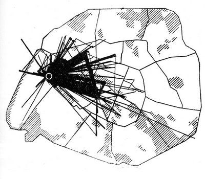
The above map was referenced in the first article of the international situationist magazine in 1958 (though the map dates back to slightly before that). It was slipped in at the last minute in place of a psychogeographic study of Venice which never arrived (its author, Ralph Rumney, was the founder of the Psychogeographic Society of London. He was gobbled up by the bohemian life of the Italian city, and was expelled by the furious situationist movement for this fiasco.
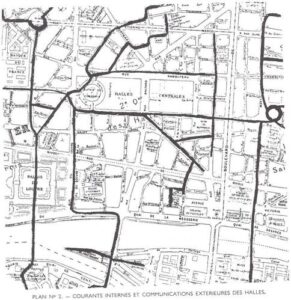
Pshychogeographic study of the Les Halles market, Paris, by A. Khabit. Issue 2 of the Situationist International Magazine, 1958.
6 months later, the second issue of the Situationist International Magazine was published. It contained a study about understanding the workings of the Parisian neighbourhood Les Halles (a major interchange and frontier between working-class Paris and more upmarket areas), especially as night fell, through data collection and direct observation. The study was also never completed, this time due to its author, a North-African, repeatedly violating the law which prohibited North Africans from being on the street past 9 o’ clock at night.
This study, however, provides highly valuable information on the most used internal corridors, like those most used to access Les Halles. More than 60 years later, banks like BBVA use big data generated from our purchases to represent the workings of barrios in Madrid, or of key commercial areas in Madrid or Barcelona. This information can be exploited to adjust rent for commercial buildings according to their importance of each business for the collective.
In the present era of cities, it’s important for their councils to take part in this data analysis and the action taken subsequently. It is the only way to guarantee that this big data and artificial intelligence is used to benefit everyone.
Since the 60s and 70s, urban planners like Jan Gehl and Allan Jacobs based their work on carefully observing and taking note of the trajectory of people in squares and streets. They did this because this plethora of data acquired could be then used to make those squares and streets better designed, as demonstrated in their respective books How to Study Public Life and Great Streets.
Today, an urban planner’s notebook is complemented with databases, and the maps which they produce are no longer limited to a street or neighbourhood, as computation allows them to create entire city models.

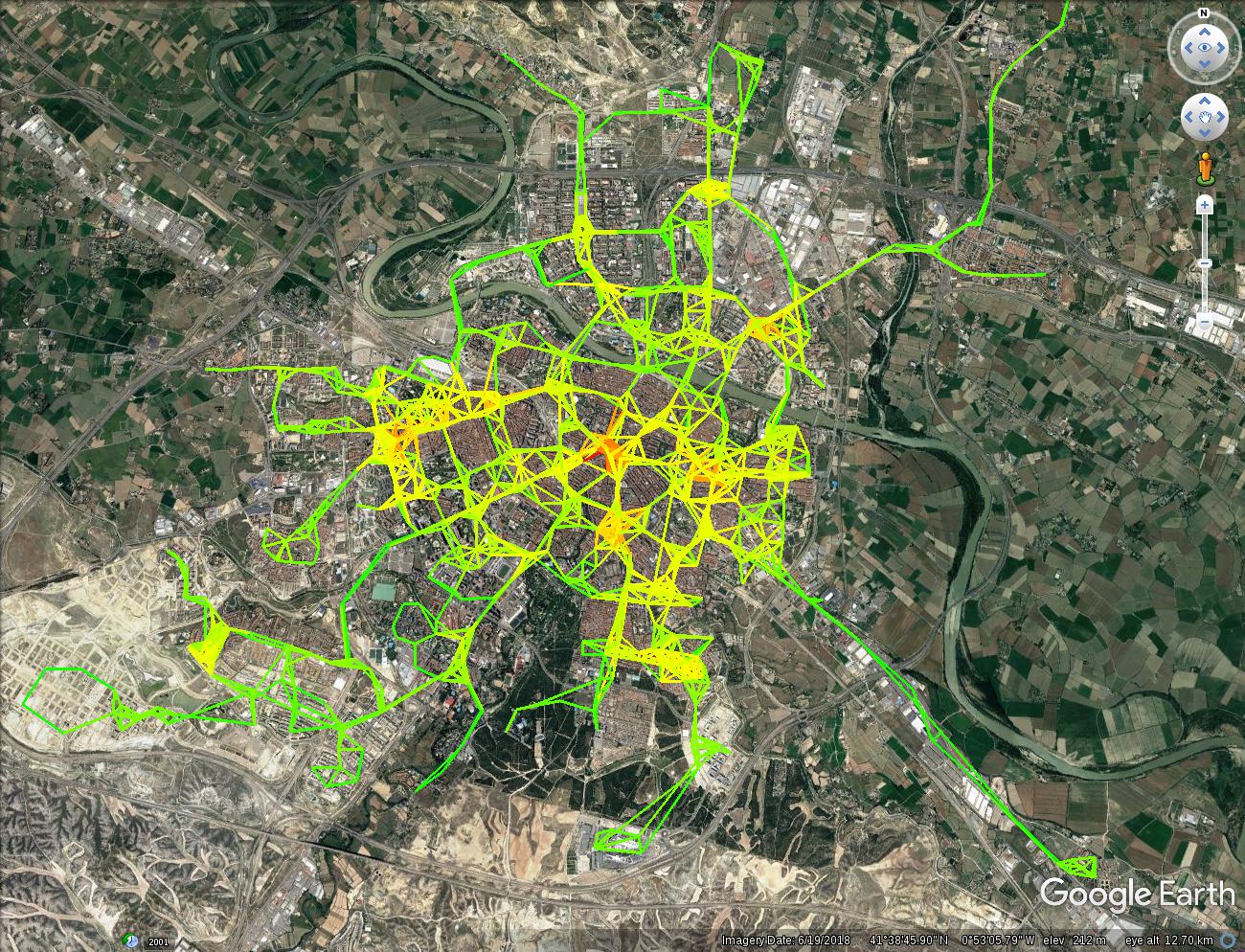
The hidden interchange points in Zaragoza, by Eduardo Aguerri. 2018
In 2015, I published my work on the construction on the creation of this “hubble” telescope of cities”, which will allow us to better understand this expanding universe of urban “big data” (with its own particle energy and dark matter). As well as BBVA’s project I studied the work of the CASA (Centre for Advanced Spatial Analysis) at UCL, London and the MIT Senseable City Lab in Boston. Nevertheless, the use of analytics and visualization of Big Data has since broken through the limited walls of the investigation centres and of large corporations like Facebook.
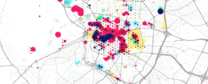
Where tourists walk in Madrid, by 300.000km.net. 2019.
There are many steps left to take in order to unlock the potential of the data goldmine, on which cities are perched, for the good of their citizens. There must be more involvement from civic, scientific and creative local communities. The data must be made easier to understand. We must try to go beyond “big data” towards “open big data”. We must also explore those data repositories which are in private hands (the vast majority). And finally, we must try to connect citizen participation initiatives with this newly-created knowledge, as cities are not decided from the top nor bottom, but in cooperation.
This week, we launched the “Ojo al Dato. Esto se mueve” program at the Open Urban Lab, aiming in some of the following directions: at the last Ideathon 100ideasZGZ on mobility we launched an innovation program to shed new light on the functioning of the city using data from vehicles, pedestrians, cyclists, urban transport users and ATM and store transactions. Apps, gadgets, visuals, videos, all formats were accepted for the challenge. Furthermore, two 20-hour courses on training for analytics and visualization of data for all types of possible candidates are available within the programme.
And our work this last year in Zaragoza as the coordinators of Eurocities is also headed in the same direction – to forward Data People Cities, in which the value of urban data is recognized as a benefit for all. The town councils act as mediators here between different urban innovation agents, each citizen having the final say in their own data and privacy.
Going back to situationists, their first magazine issue had an editorial entitled; “The bitter victory of surrealism”. The article justifies the start of this new movement, noting that capitalism had appropriated the surrealist techniques (e.g. brainstorming, or tools for suggestion such as subliminal advertising) to ensure the continuance of a consumerist society. The phenomenon of a dominating culture absorbing and banalizing the pioneer is not a new one. Works of the situationists have been manifested in ephemeral urbanism, from projects like “Resurrection city” by Martin Luther King Jr. to Madrid’s “Campo de Cebada”, the breeding ground of the 15M movement. As we have seen, smartphones, geolocation and data analytics are starting to make urban psychogeography a reality in the present day. If city and town councils do not take that step forward, it will be, yet again, the big corporations who will plan urban areas at their own will through information generated by these new psychogeographic techniques. If this were to be the case, the victory of situationists would be just as bitter as the victory of their surrealist grandparents decades earlier.
This article is published under a Creative Commons license. Some rights reserved.


